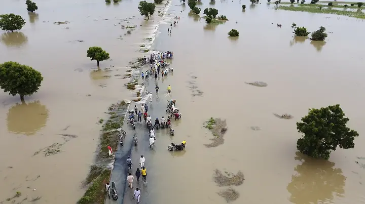
ABUJA, Nigeria — Nigeria’s hydrological agency has warned of high riverine flood risk across parts of 15 states through 25 September, advising exposed communities to monitor river levels and move people, livestock and valuables to safer ground where necessary.
The National Flood Advisory identifies more than 8,000 communities and over 4,500 schools within exposure areas, according to Nigerian reports carrying the agency’s assessment. The figures describe locations at risk; they are not a confirmed count of places already flooded.
Which Nigerian states are covered by the latest flood warning?
NiHSA’s seven-day advisory covers exposed areas in Imo, Cross River, Delta, Ebonyi, Benue, Anambra, Akwa Ibom, Edo, Enugu, Bayelsa, Kogi, Abia, Taraba, Rivers and Lagos through 25 September. Risk varies by community and river basin.
The 15 states named in the advisory
The warning covers vulnerable areas in Imo, Cross River, Delta, Ebonyi, Benue, Anambra, Akwa Ibom, Edo, Enugu, Bayelsa, Kogi, Abia, Taraba, Rivers and Lagos.
The International Centre for Investigative Reporting identified the advisory as NFA-2026-262 and said it runs from 19 to 25 September. NiHSA Director-General Umar Mohammed said rising river stages could cause flooding and identified nine river stations requiring close monitoring.
Stations highlighted in the public account include Obubra, Itigidi and Epento on the Cross River. Residents should use the NiHSA flood dashboard and state emergency notices for the latest local position rather than assuming conditions are identical across an entire state.
Thousands of communities and critical facilities are exposed
Nigeria Info reported that more than 8,000 communities and 4,500 schools fall within the advisory’s exposure areas. Healthcare facilities, markets, religious buildings and farmland are also listed in the assessment.
NATURAL DISASTERS
Nigeria Flood Warning Covers 15 States Through September 25

Sep 21, 2026
Sep 21, 2026
4 min read
Published
Updated:
ABUJA, Nigeria — Nigeria’s hydrological agency has warned of high riverine flood risk across parts of 15 states through 25 September, advising exposed communities to monitor river levels and move people, livestock and valuables to safer ground where necessary.
The National Flood Advisory identifies more than 8,000 communities and over 4,500 schools within exposure areas, according to Nigerian reports carrying the agency’s assessment. The figures describe locations at risk; they are not a confirmed count of places already flooded.
Which Nigerian states are covered by the latest flood warning?
NiHSA’s seven-day advisory covers exposed areas in Imo, Cross River, Delta, Ebonyi, Benue, Anambra, Akwa Ibom, Edo, Enugu, Bayelsa, Kogi, Abia, Taraba, Rivers and Lagos through 25 September. Risk varies by community and river basin.
The 15 states named in the advisory
The warning covers vulnerable areas in Imo, Cross River, Delta, Ebonyi, Benue, Anambra, Akwa Ibom, Edo, Enugu, Bayelsa, Kogi, Abia, Taraba, Rivers and Lagos.
ADVERTISEMENT
The International Centre for Investigative Reporting identified the advisory as NFA-2026-262 and said it runs from 19 to 25 September. NiHSA Director-General Umar Mohammed said rising river stages could cause flooding and identified nine river stations requiring close monitoring.
Stations highlighted in the public account include Obubra, Itigidi and Epento on the Cross River. Residents should use the NiHSA flood dashboard and state emergency notices for the latest local position rather than assuming conditions are identical across an entire state.
Thousands of communities and critical facilities are exposed
Nigeria Info reported that more than 8,000 communities and 4,500 schools fall within the advisory’s exposure areas. Healthcare facilities, markets, religious buildings and farmland are also listed in the assessment.
Cross River’s exposed area includes 2,471 communities, 703 schools and 344 health facilities. In Imo, the assessment identifies 958 communities, 1,022 schools and 553 health facilities. Ebonyi and Anambra also contain large numbers of exposed schools and communities.
These are planning figures, not a forecast that every listed building will flood. River levels, rainfall, drainage, elevation and local protective measures will determine the actual impact. Schools and health facilities should follow instructions from state and local emergency agencies, particularly where access roads or bridges may become unsafe.
ADVERTISEMENT
What residents in flood-prone areas should do
NiHSA advised communities on floodplains to prepare to move to higher ground. It also urged authorities to identify safe shelters, pre-position clean water, first-aid materials and relief supplies, and activate local early-warning arrangements.
Nigeria’s National Emergency Management Agency gives three immediate precautions:
Follow official alerts and relocate early when local authorities advise it.
Do not walk or drive through floodwater, flooded bridges or fast-moving water.
Keep drainage channels clear where it is safe to do so and report emergencies promptly.
Families should move medicines, identity documents, phones, chargers and essential supplies into waterproof bags before water begins rising. Livestock and vehicles should be moved early because evacuation routes can become impassable quickly.
People should not wait for viral videos before acting. A flooded road can conceal washed-out surfaces, open drains, electrical hazards or strong currents.
NiHSA provides national hydrological monitoring, while NEMA, State Emergency Management Agencies and local authorities coordinate preparedness and response. A national list does not replace a community-level evacuation order.


POPULAR TODAY


ADVERTISEMENT
The NiHSA website publishes flood outlooks and monitoring information. NEMA’s review of the 2026 flood season says effective preparedness depends on warnings being translated into local action before roads, homes and services are cut off.
XTRAfrica’s Nigeria government-services page collects practical public-service guides. Earlier emergency reporting on the Okrika jetty deaths also showed why authorities must separate verified official information from rapidly circulating casualty claims.
NiHSA said it would continue monitoring river levels and issue further updates as conditions change. State governments, schools and community leaders should identify the exact LGAs and settlements named in the full advisory and communicate shelter or closure decisions directly.
The warning expires on 25 September unless it is extended or replaced. Residents should keep checking NiHSA, NEMA and state emergency channels because a forecast can be revised as rainfall and upstream river levels change.
ADVERTISEMENT
RELATED ARTICLE


